
En Son Sürüm
Sürüm
1.5.0
1.5.0
Güncelle
Ekim 09, 2025
Ekim 09, 2025
Geliştirici
4Digsoft
4Digsoft
Kategoriler
Araçlar
Araçlar
Platformlar
Android
Android
İndirme
0
0
Lisans
Ücretsiz
Ücretsiz
Paket Adı
glandgo.gpsarea.fieldareameasure
glandgo.gpsarea.fieldareameasure
Bildir
Sorun Bildir
Sorun Bildir
GPS Field Measure - GLandGo Hakkında Daha Fazla
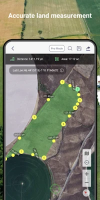
Measure land area, distance, and perimeter with precision using your device's GPS.
GLandGo is the smart, reliable, and professional GPS Area Measurement app designed for accurate land surveying. Whether you’re measuring fields, tracking distances, or managing land data, GLandGo gives you full control — right from your mobile device.
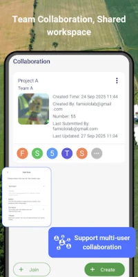
✅Major Update: Collaboration Mode Now you can create projects, add multiple accounts, and work together with your team. All members’ measurement records are synced in real time, and different project roles come with different permissions – making teamwork smooth and efficient.
🌍 Key Features:
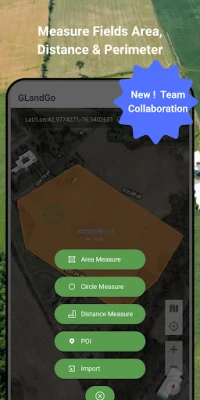
1. GPS Area Measurement
Measure land by walking the perimeter or placing points manually on the map.
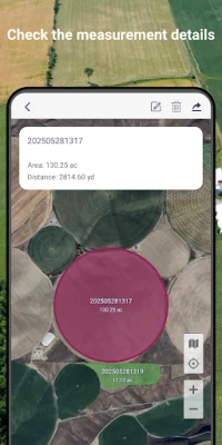
Save results with names, notes, photos, and categories.
Multiple units supported: hectares, acres, square meters, etc.
2. Distance Measurement
Track path lengths and calculate straight-line or multi-point distances.
Supports GPS tracking and manual distance input.
3. Manual Coordinate Input
NEW: Precisely add points by entering latitude and longitude.
Useful for remote mapping and GPS data referencing.
4. Location Marking & Organization
Save and categorize important locations for future reference.
5. GPS Tools & Navigation
Built-in compass for field alignment.
Real-time GPS tracking, direction, and satellite positioning.
6. Import & Export Support
Import: SHP, GeoJSON, KML, KMZ
Export: SHP, KML, JPG, PDF, GeoJSON
Share measurement results via custom web links.
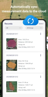
7. GLandGo Cloud
Protect your data with built-in cloud/local backup options.
8. Professional Mapping Support:
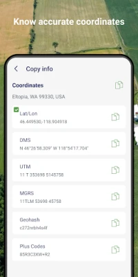
Coordinate formats: DMS, UTM, MGRS, Plus Code, Geohash
Map history tracking
Customizable map types and themes
9. Collaboration – add multiple users to projects, assign roles, and collaborate with real-time data sync
10. Cross-Platform Sync - Log in with your account and seamlessly access your data across both Android and iOS devices. Whether you switch phones or use multiple platforms, your data stays synchronized in the cloud.
11. Circle Area Measurement – Quickly measure circular plots of land by setting the center and radius.
12. Manual Coordinate Entry – Add precise location points by entering coordinates manually.
👥 Perfect For:
Farmers & Agronomists
Land Surveyors
Real Estate Professionals
Engineers & Architects
Environmental Planners
Outdoor Enthusiasts & Hikers
GIS Survery
GLandGo is your GPS Fields Area Measure Map, Map Area Calculator, Field Area Measure, and GPS Land Measurement & Survey solution – smart, simple, and accurate.
Download GLandGo – GPS Area Measurement today and experience the easiest and most powerful way to measure land and distances anywhere.
✅Major Update: Collaboration Mode Now you can create projects, add multiple accounts, and work together with your team. All members’ measurement records are synced in real time, and different project roles come with different permissions – making teamwork smooth and efficient.
🌍 Key Features:
1. GPS Area Measurement
Measure land by walking the perimeter or placing points manually on the map.
Save results with names, notes, photos, and categories.
Multiple units supported: hectares, acres, square meters, etc.
2. Distance Measurement
Track path lengths and calculate straight-line or multi-point distances.
Supports GPS tracking and manual distance input.
3. Manual Coordinate Input
NEW: Precisely add points by entering latitude and longitude.
Useful for remote mapping and GPS data referencing.
4. Location Marking & Organization
Save and categorize important locations for future reference.
5. GPS Tools & Navigation
Built-in compass for field alignment.
Real-time GPS tracking, direction, and satellite positioning.
6. Import & Export Support
Import: SHP, GeoJSON, KML, KMZ
Export: SHP, KML, JPG, PDF, GeoJSON
Share measurement results via custom web links.
7. GLandGo Cloud
Protect your data with built-in cloud/local backup options.
8. Professional Mapping Support:
Coordinate formats: DMS, UTM, MGRS, Plus Code, Geohash
Map history tracking
Customizable map types and themes
9. Collaboration – add multiple users to projects, assign roles, and collaborate with real-time data sync
10. Cross-Platform Sync - Log in with your account and seamlessly access your data across both Android and iOS devices. Whether you switch phones or use multiple platforms, your data stays synchronized in the cloud.
11. Circle Area Measurement – Quickly measure circular plots of land by setting the center and radius.
12. Manual Coordinate Entry – Add precise location points by entering coordinates manually.
👥 Perfect For:
Farmers & Agronomists
Land Surveyors
Real Estate Professionals
Engineers & Architects
Environmental Planners
Outdoor Enthusiasts & Hikers
GIS Survery
GLandGo is your GPS Fields Area Measure Map, Map Area Calculator, Field Area Measure, and GPS Land Measurement & Survey solution – smart, simple, and accurate.
Download GLandGo – GPS Area Measurement today and experience the easiest and most powerful way to measure land and distances anywhere.
Uygulamayı Puanlayın
Yorum ve Değerlendirme Ekle
Kullanıcı Değerlendirmeleri
0 değerlendirmeye göre
Henüz değerlendirme eklenmedi.
SPAM, kötüye kullanım içeren, konu dışı, küfür barındıran, kişisel saldırı içeren veya herhangi bir türde nefret söylemi barındıran yorumlar yayınlanmak üzere onaylanmaz.


Daha Fazla »

Popüler Uygulamalar

Santander Connect UKSantander UK plc

Santander AmexBanco Santander (Brasil) S.A.

اسکل خان : فیلم و سریالHans Schmidt Koblenz

FreeReels: Dramalar ve DizilerSKYWORK AI PTE.LTD.

TUDU: YKS’ye HazırlanTUDU TEKNOLOJI AS

Çorak diyarın hikayesi: UyanışLunarite Studio

WhatsApp BusinessWhatsApp LLC

Safra Empresas: A sua conta PJBanco Safra SA.

Car Parking Multiplayerolzhass

WhatsApp MessengerWhatsApp LLC