

En Son Sürüm
Sürüm
2024-09-22 23
2024-09-22 23
Güncelle
Ekim 06, 2025
Ekim 06, 2025
Geliştirici
Smart Cities Transport, Sydney NSW, Route Planners
Smart Cities Transport, Sydney NSW, Route Planners
Kategoriler
Seyahat & Yerel
Seyahat & Yerel
Platformlar
Android
Android
İndirme
0
0
Lisans
Ücretsiz
Ücretsiz
Paket Adı
waverley.transport.maps.transit.timetable
waverley.transport.maps.transit.timetable
Bildir
Sorun Bildir
Sorun Bildir
Waverley Transport: Maps, Time Hakkında Daha Fazla
Waverley Transport app is great as a route planner including private and public transport. With a tap on your phone you can - Get directions, city maps, timing, train & bus timetable, check fares, save favourite stops & get real-time information for all transit types. The app provides you the efficient and affordable ways to commute and travel across Sydney & NSW.
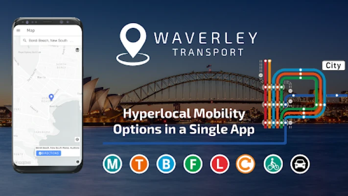
Waverley Transport is your mobility partner to guide & plan your journey with all transport modes:- 🚍 bus 🚆 train 🚇 metro 🚋 tram ⛴ ferry 🚕 ride services 🚗 wheelchair accessible taxi 🚙 car share 🚴 bicycle and🚶walking
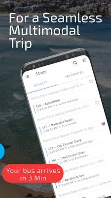
Find the closest stop, and easily check which ride is next there!
FEATURES OF WAVERLEY TRANSPORT:
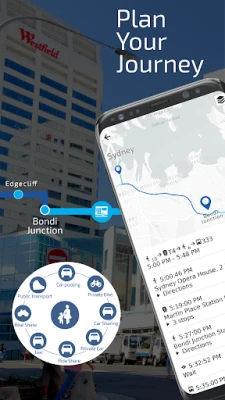
✔️ Detailed directions across combinations of transport modes (public & private). Find the best combinations of trips to your destination.
✔️ Provides safe and continuous routes for trams, wheelchairs, and children on bicycles
✔️ Step-by-step directions, details of street-by-street turns, stop-by-stop timings, wait timings etc.
✔️ Encourages the use of designated safe pick-up/drop-off (PUDO) zones
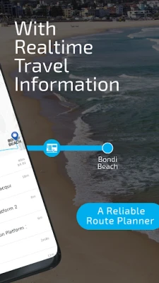
✔️ Reliable route planner - Know Train & Bus timetable to check out which ride is next there!
✔️ Trip planner with city maps, fare estimates, vehicle operating costs, tolls, etc.
✔️ Save bus stops and train stations.
✔️ EV charging locations to plan longer transit trips 🔌⚡💡
✔️ Personalize your trips by picking your route preferences.
ONE APP FOR ALL TRANSPORT MODES FOR SYDNEY NSW TO REACH NEXT THERE STOP:
Public transport includes trains, metro trains, buses, ferries, and light rail trams. Private transport includes rental cars, ride services, car share, cab, taxi, wheelchair taxi, walking, cycling etc.
🚉 Major Sydney NSW trains interchanges: 🚉
⚬ Central Station
⚬ Chatswood Station
⚬ Circular Quay Station
⚬ North Sydney Station
⚬ Parramatta Station
⚬ Town Hall Station
⚬ Bondi Junction Station
🚏 Major bus stops: 🚏
⚬ Bondi Beach
⚬ Westfield Bondi Junction
⚬ Maroubra
⚬ Parramatta
⚬ Randwick
⚬ Sydney CBD
⚬ Surry Hills
👉👉 Some more interesting features given below are coming soon in your trip planner app for Sydney NSW 👈👈
📱 LIVE Maps & Notifications during your trip
↗️ Turn-by-turn Navigation
📥 Save Favorite Destinations
& many more..
So, why wait! Let’s make your trip easy.
➡️➡️➡️ Download Waverley Transport App and route planner and check train & bus timetable, as well as other private and public transport options and city maps.
Keep in touch❤️ If you have questions or any feedback for us, email us at waverley.play@SmartCitiesTransport.com
Ride with the best. Ride the Waverley!
Find the closest stop, and easily check which ride is next there!
FEATURES OF WAVERLEY TRANSPORT:
✔️ Detailed directions across combinations of transport modes (public & private). Find the best combinations of trips to your destination.
✔️ Provides safe and continuous routes for trams, wheelchairs, and children on bicycles
✔️ Step-by-step directions, details of street-by-street turns, stop-by-stop timings, wait timings etc.
✔️ Encourages the use of designated safe pick-up/drop-off (PUDO) zones
✔️ Reliable route planner - Know Train & Bus timetable to check out which ride is next there!
✔️ Trip planner with city maps, fare estimates, vehicle operating costs, tolls, etc.
✔️ Save bus stops and train stations.
✔️ EV charging locations to plan longer transit trips 🔌⚡💡
✔️ Personalize your trips by picking your route preferences.
ONE APP FOR ALL TRANSPORT MODES FOR SYDNEY NSW TO REACH NEXT THERE STOP:
Public transport includes trains, metro trains, buses, ferries, and light rail trams. Private transport includes rental cars, ride services, car share, cab, taxi, wheelchair taxi, walking, cycling etc.
🚉 Major Sydney NSW trains interchanges: 🚉
⚬ Central Station
⚬ Chatswood Station
⚬ Circular Quay Station
⚬ North Sydney Station
⚬ Parramatta Station
⚬ Town Hall Station
⚬ Bondi Junction Station
🚏 Major bus stops: 🚏
⚬ Bondi Beach
⚬ Westfield Bondi Junction
⚬ Maroubra
⚬ Parramatta
⚬ Randwick
⚬ Sydney CBD
⚬ Surry Hills
👉👉 Some more interesting features given below are coming soon in your trip planner app for Sydney NSW 👈👈
📱 LIVE Maps & Notifications during your trip
↗️ Turn-by-turn Navigation
📥 Save Favorite Destinations
& many more..
So, why wait! Let’s make your trip easy.
➡️➡️➡️ Download Waverley Transport App and route planner and check train & bus timetable, as well as other private and public transport options and city maps.
Keep in touch❤️ If you have questions or any feedback for us, email us at waverley.play@SmartCitiesTransport.com
Ride with the best. Ride the Waverley!
Uygulamayı Puanlayın
Yorum ve Değerlendirme Ekle
Kullanıcı Değerlendirmeleri
0 değerlendirmeye göre
Henüz değerlendirme eklenmedi.
SPAM, kötüye kullanım içeren, konu dışı, küfür barındıran, kişisel saldırı içeren veya herhangi bir türde nefret söylemi barındıran yorumlar yayınlanmak üzere onaylanmaz.


Daha Fazla »

Popüler Uygulamalar
Santander Connect UKSantander UK plc

Santander AmexBanco Santander (Brasil) S.A.

اسکل خان : فیلم و سریالHans Schmidt Koblenz

FreeReels: Dramalar ve DizilerSKYWORK AI PTE.LTD.

TUDU: YKS’ye HazırlanTUDU TEKNOLOJI AS

Çorak diyarın hikayesi: UyanışLunarite Studio

WhatsApp BusinessWhatsApp LLC

Safra Empresas: A sua conta PJBanco Safra SA.

Car Parking Multiplayerolzhass

WhatsApp MessengerWhatsApp LLC